
Urban Flood Modeling and Drainage Planning for the Upper Maldonado and Cildañez Basins
High-resolution urban hydrologic–hydraulic modeling to support flood risk mapping, drainage upgrades, and inter-basin flow management in the Upper Maldonado and Cildañez basins.

Overview
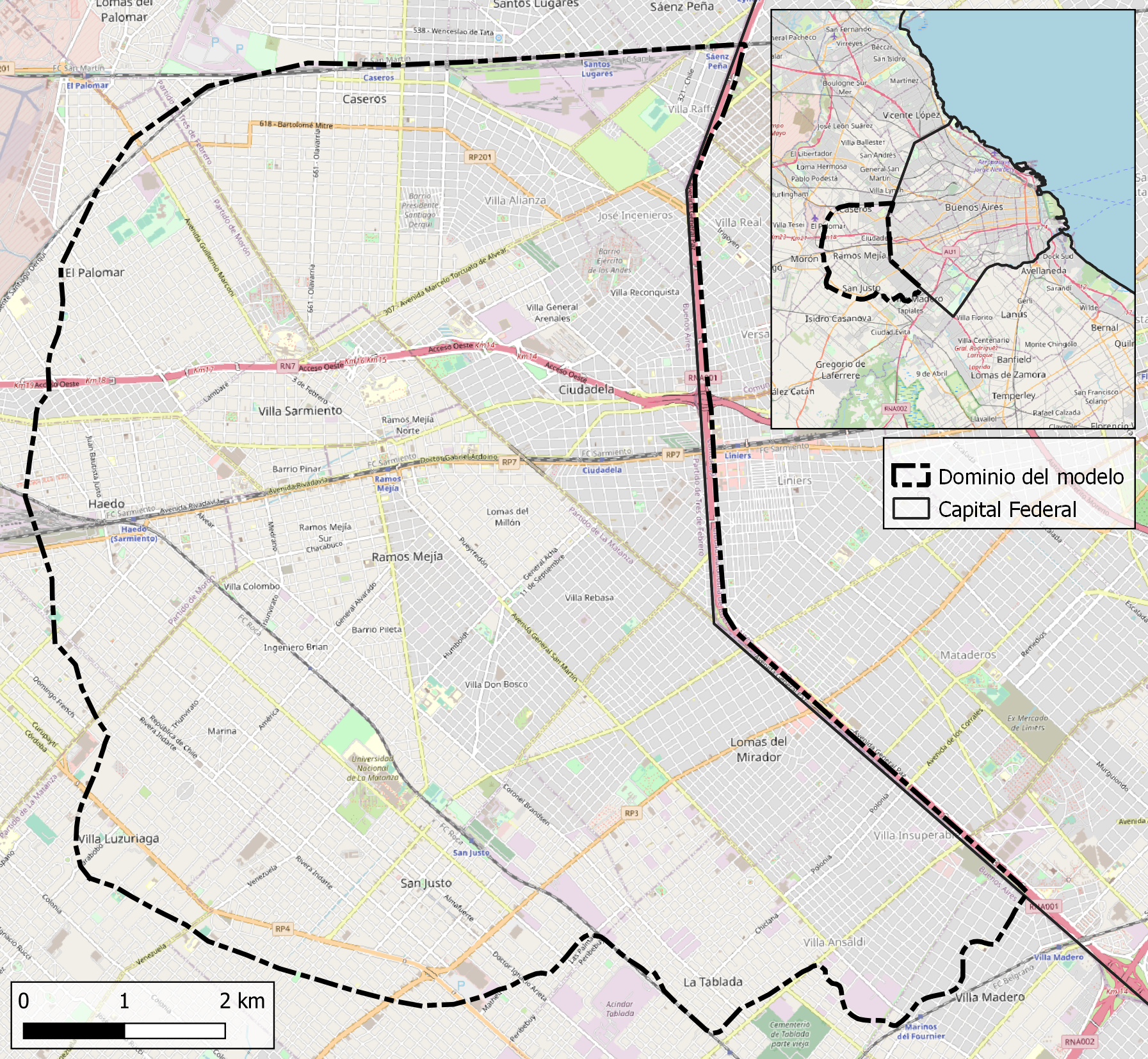
The upper basins of the Maldonado and Cildañez streams, located in the Metropolitan Buenos Aires region, experience recurrent urban flooding driven by intense rainfall, heterogeneous drainage infrastructure, and rapid urbanization. These basins discharge toward downstream urban areas, making upstream interventions critical for managing flood risk beyond local administrative boundaries.
HCS contributed to a multi-stage technical study aimed at developing a numerical modeling framework capable of representing current drainage performance, identifying flood-prone areas, and evaluating structural interventions to reduce flood impacts while controlling downstream discharges.
The Challenge
The Maldonado–Cildañez basin system presents several interconnected challenges:
- Highly urbanized catchments with mixed surface and underground drainage
- Drainage networks designed under different historical criteria
- Limited capacity in some trunk conduits
- Flooding that propagates across jurisdictional boundaries
- The need to manage upstream improvements without increasing downstream risk
Decision-makers required a tool to:
- Quantify flood hazard under different rainfall scenarios
- Identify critical locations within the drainage network
- Evaluate the effectiveness of proposed drainage upgrades
- Assess how upstream improvements affect downstream discharges
- Support a long-term hydraulic planning strategy at basin scale
Our Contribution
HCS developed a high-resolution urban hydrologic–hydraulic model covering the upper portions of both basins, integrating rainfall–runoff processes with detailed drainage representation.
1. Integrated Urban Drainage Modeling
The modeling framework represents the dual drainage system, including:
- Underground stormwater conduits
- Open channels and trunk collectors
- Surface flow along streets and avenues
- Hydraulic connections between surface and subsurface systems
This approach allows the model to reproduce both pipe flow and street flooding, which is essential for realistic urban flood assessment.
2. Data Integration and Model Construction
The model was built using:
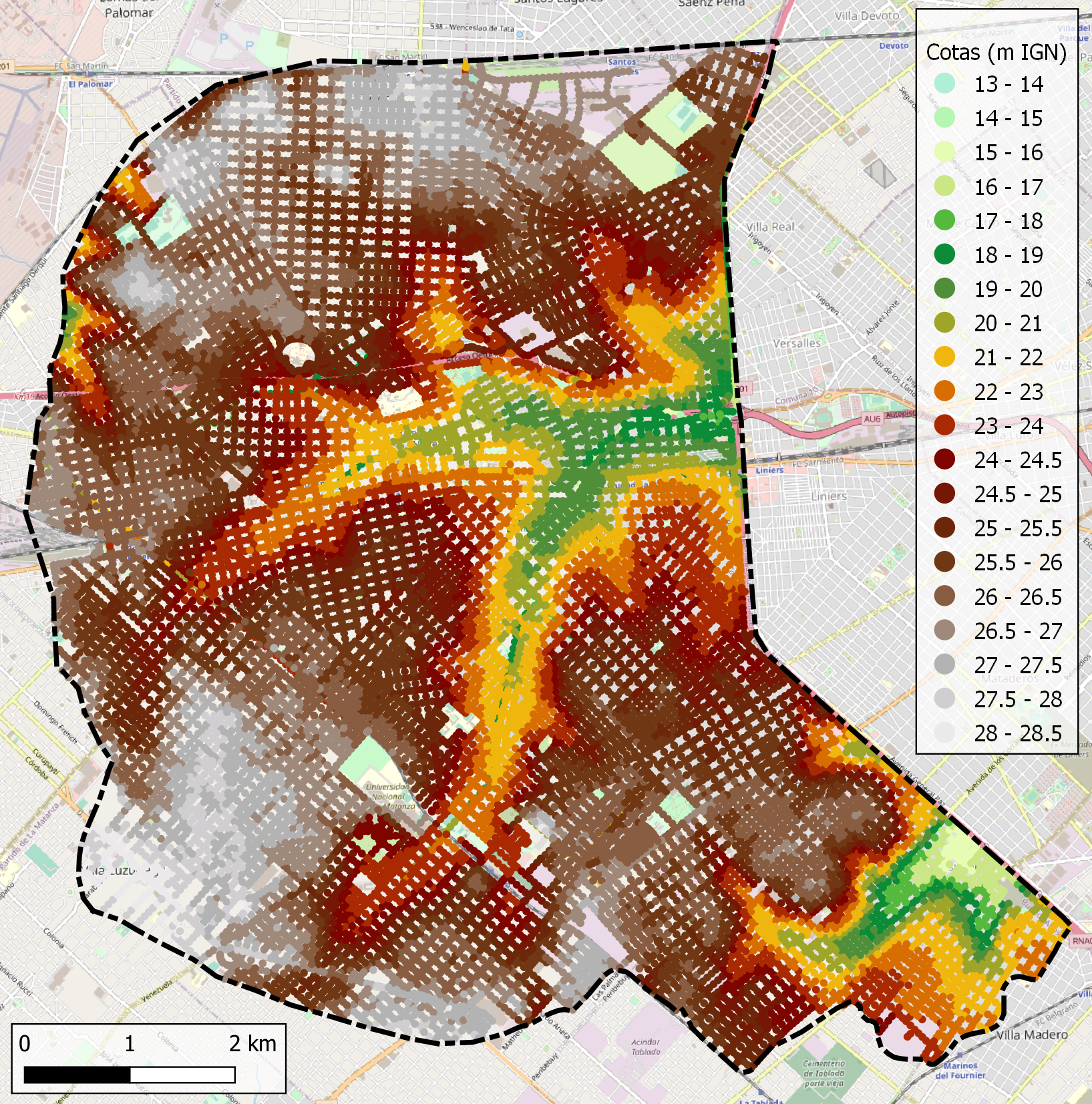
- High-resolution digital elevation models
- Detailed street layouts and drainage networks
- Updated information on trunk conduits and key structures
- Basin discretization into a large number of subcatchments
Automated GIS-based routines were used to ensure consistency between topography, drainage geometry, and surface flow paths.
3. Model Validation and Flood Mapping
The model was tested and refined through comparison with:
- Known flood-prone locations
- Historical records of inundation
- Observed system behavior during significant rainfall events
Once validated, the model was used to generate flood maps showing:
- Maximum water depths in streets
- Flow velocities
- Combined flood hazard indicators based on depth and velocity
These maps provided a spatially explicit view of flood risk across the basin.
4. Evaluation of Drainage Improvement Scenarios
Using the validated model, HCS evaluated multiple intervention scenarios, including:
- Enlargement of selected conduits
- Addition of new drainage links
- Improvements to network connectivity
- Redistribution of flows within the system
The objective was to achieve acceptable flood conditions for design storms while avoiding adverse impacts elsewhere in the basin.
5. Management of Downstream Discharges
An essential component of the study was assessing how upstream drainage improvements affect exported flows toward downstream urban areas. The modeling framework was used to:
- Quantify changes in basin outflows
- Identify the need for complementary mitigation measures
- Support the conceptual design of interception or relief structures
This ensured that local improvements would not transfer flood risk downstream.
Key Findings
The modeling work demonstrated that:
- High-resolution urban models are essential to capture combined surface–subsurface flooding processes
- Targeted drainage upgrades can significantly reduce flood depths in critical areas
- Basin-wide analysis is necessary to manage interdependencies between subcatchments
- Upstream improvements must be accompanied by flow management strategies to control downstream impacts
- Numerical modeling provides a robust basis for prioritizing investments in complex urban basins
Outcomes and Client Value
Through this project, HCS delivered:
- A validated urban flood modeling framework at basin scale
- Flood hazard maps to support planning and risk communication
- Technical support for drainage upgrade design
- Quantitative assessment of downstream flow implications
- A defensible basis for long-term hydraulic planning
This case study highlights HCS’s expertise in urban flood modeling, integrated drainage analysis, and basin-scale hydraulic planning for densely populated metropolitan environments.
Contact
Request a consultation
Have a hydraulic challenge? Let's discuss how we can help.
Call Us
+54 2324 550433